GRID Release Notes
This page lists the release notes from every production version* of the GRID Product starting from January, 2017 when this
page was created. Gaia Resources would like to acknowledge the contributions from NRM Group champions in making enhancement
suggestions and testing, which is an integral part of the process of continually improving the GRID product. * unless noted
as “currently on testing instances only”
Version 1.5.7 – 07/06/2018
The following bugs were resolved in this release:
- Inability to edit baselayer symbology
- Non-administrators were unable to edit user layer symbology
- When a feature was set to ‘symbolise by attribute’, labels would not appear on the map
Version 1.5.6 – 18/05/2018
The following minor updates have been applied to this release:
- Baselayer symbology by attribute: similar function to previous Activity symbology by attribute, the administrator can
now choose an attribute field in a shapefile and set the symbology settings for each unique value detected in the
data for that field. A limit of 12 unique entries can be symbolised, and the remaining entries are grouped in a 13th
“All other” category for the purposes of displaying on the map. - My GIS symbology by attribute: in the same way as a Baselayer symbology can now be based on attribute values, end users
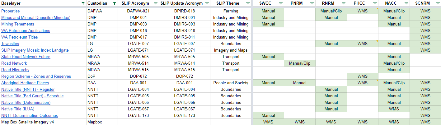
also have this feature available to them for My GIS content. - 13 base layers were reviewed and manually updated across four NRM GRID instances in this reporting period. These include
layers that are updated frequently by custodians, where individual NRM groups have requested a manual update.
In other cases, NRM groups have opted for the configuration or web map services so they can take advantage of live
links to the data
layers directly from the government custodian. The following
layers were manually updated:- Properties (DPIRD-018)Mines and Mineral Deposits (DMIRS-001)Mining Tenements (DMIRS-003)• Townsites (LGATE-007)
- State Road Network Future (MRWA-505)
- Road Hierarchy (MRWA-515)
- Road Network (MRWA-514)
- Aboriginal Heritage Places (DAA-001)
- Native Title layers (LGATE-066, LGATE-005, LGATE-067, LGATE-004, LGATE-173)
- See summary table:

Version 1.5.2 – 1.5.5 – 04/2018
The following minor updates have been applied to this release:
- Program filter in the Edit Activity panel: within the Add and Edit window the user can now filter the list of projects
by first selecting a Program which reduces the Project listing - Activity description (Admin): when editing an Activity schema, the Administrator can now add a description of the activity
type. - Bug fix: map report now includes WMS layers display and symbology is included in the legend
- Bug fix: missing symbology for ‘other’ types resolved
- Using numbers in field headings is now supported

Version 1.5.1 – 15/11/2017
The following minor updates have been applied to this release:
- Bug fix: info and select tool hanging under certain circumstances has been resolved
- Edit Project “Parent” field has been reworded and re-ordered in the form to indicate this is for defining a sub-project
(e.g. specify the Parent project – if applicable) - Edit Project page now has an optional “Managed by” field that can be used to track whether the project is ‘Internally
managed’ or ‘Externally managed’
Version 1.5 – 24/10/2017
The following is a list of features and fixes that have been applied in this release:
- Group permissions setup: The Administrator can assign individual logins to a Group within the Admin module.
- Base layer permissions: the Administrator has the ability to control visibility of Base Layers in GRID by assigning Groups
to them in the Admin module. - Project permissions: the Administrator can control the projects that are available for editing in the drop-down list
on the Add and Edit module, by assigning Groups to them in the Admin module. - Activity permissions: the Administrator can control both the visibility and edit ability of Activities by assigning Groups
to them in the Admin module. Within the Activity settings, the Administrator can choose to allow ‘view-only’ or ‘view
and edit’ for each assigned Group. - Assigned Groups are now available as a field inside Project, Activity and Base Layer lists.
- The Administrator can assign admin privileges to another user.
- Filter drop-down lists are now alphabetically ordered
- Bug fix: Date range filter/export problem has been resolved so that features with the correct date range are exported.
- Bug fix: Administrators now cannot add special characters to Activity and Base Layer names (e.g. commas, colons, semi-colons,
slashes, ampersands), which were causing error messages and unexpected behaviour. - Bug fix: User who is granted Admin privileges was receiving a Forbidden error on some actions
- Bug fix: Hierarchy for Organisations and Programs are now enforced. A migration has been applied to set a default Program
and Organisation to orphaned records. - Bug fix: When no Groups are applied to Projects, Activities and Base Layers, the default behaviour is now to show that
content rather than hide it. This content then becomes visible/hidden when a Group is applied. - Bug fix: Layers symbolised by attribute now work on map report legends (note: large legends may no longer fit within
the template) - Bug fix: WMS layer symbology now shows on map report legend (note: large legends may no longer fit within the template)
- Bug fix: Saving a User Layer setting no longer returns to the Baselayers list


Version 1.4 – 27/09/2017
The following is a list of features and fixes that have been applied in this release:
- Symbolise by attribute for Activities: the Administrator can select a Single Select field on which to base multiple symbology
properties. - Symbolise by attribute: once configured the new symbol properties are displayed in the map view, and a patch is available
to hover over and see what values the different colours and patterns relate to.
Version 1.3 – 13/09/2017
The following is a list of features and fixes that have been applied in this release:
- Filter tab: reset button only appears when a filter has been applied
- Filter tab: selected filter items are now visible on the right hand side
- Filter tab and Activities Admin page: activity date range filter is now configurable by the Admin and can be based on
any date field - Map tool tips: tool name and descriptions now provided when hovering over a tool
- Report button and page added, filters applied in Add & Edit Data or View Data are carried through to Report page
- Report page: ability to export filtered Activity results to a zip folder containing Excel and/or shapefiles and/or attachments
- Excel report contains a summary statistics worksheet, and one worksheet for filtered results from each Activity
- Shapefile type export contains up to three shapefiles for each Activity, with features representing the results of the
filters applied
The following is a list of features and fixes were developed in an initial update and are also part of this release:
- Filtering tab, where activities (on Add and Edit Data, and View Data) are dynamically filtered on the map based on drop-down
lists for Organisation, Program, Project, Owner, or Date Range - Spatial filter button where the drop-down filter choices can be further refined through a extent drawn by the user on
the map - Search Activities by Spatial Extent button where the user can draw an extent on the map and have all Activities turned
on that have intersecting features - Filtering tab displays in bold when filters are applied
Version 1.2 – 12 May, 2017
The following is a list of features and fixes that have been applied in this release:
- Info tool now reveals attribute data from WMS layers
- Legend graphics (where available from the publisher) can now be viewed from WMS layers
- An alternative legend graphic URL can be specified in the WMS layer configuration page
- Coordinate Reference Systems required by each GRID instance are now included in the coordinate widget popup
- Improved handling of some WMS URLs when configuring a new Base Layer
- Bug fix: resolved an issue where large Legend graphics from the Table of Contents were obscured by the map window
- Bug fix: resolved an issue where some Legend graphics would not pop up
Version 1.1.0 – 17 March, 2017
The following is a list of features and fixes that have been applied in this release:
- Data Tables (jQuery plug-in) provides functionality to select single/multiple entries and configure number of records
per page. Available under Admin page within Activities, Base Layers and Public Layers. - Export one or many activities allows for a single Excel spread sheet as per the last release, but with only the user
selected activities - Import one, many or all activities read from an Excel spread sheet that was the output of the Export activities workflow
- Base layer picker for WMS connection (e.g. where a WMS Category URL is provided)
- Add WMTS layer, with authentication support
- Contributor logos added with each release
- Bug fix: Absolute coordinates widget moved, and decimal places for projected coordinates removed (e.g. rounding applied)
- Bug fix: Map reports was not working correctly
- Bug fix: Shapefile and Excel reports not providing correct messaging for Program and Project drop-down lists
Version 1.0.70 – 20 February, 2017
In this release a number of software updates were made, together with the following feature enhancements and bug fixes:
- Export all activities (including schema and symbology parameters) into an Excel spread sheet
- Updates to footer layout
- Bug fix: WMS layer was not displaying in the map interface for Chrome and Internet Explorer
- Bug fix: multi-select field was not working with bulk upload
Version 1.0.69 – 03 February, 2017
In this release a number of infrastructure software updates were made, together with the following feature enhancements:
- Downloadable base layers: Administrators can now configure a base layer as downloadable for users
- Metadata: Administrators can upload a standard metadata file associated with a base layer that users can then download
- Multi-select: An activity can be configured with a multi-select field, where the user can select more than one value
per field when adding or editing a feature - Version number: the version number is now displayed on the bottom banner of the GRID interface
- Release notes: a link to this page has been added to the bottom banner of the GRID interface
- Enter absolute coordinates: a widget allows the user to add a point location by typing in the coordinates, GRID will
then zoom to and centre the map extent. - WMS with authentication support: username and password can now be entered to access WMS authenticated services like SLIP
(Note: only single layer URLs with a LayerID are supported at this time)